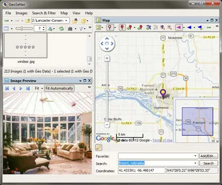
GeoSetter is a is a free image geo data and exif data tool. It can be used to display, change, add, or remove geo tags from photos and view or edit related (IPTC/XMP/Exif) metadata of pictures taken with digital cameras. You can even use it to change EXIF date of your pictures.
A zipped version is also made available that allows the user to store and run the tool from a USB thumb drive.
Geo Tagging Exif Metadata Editor | GeoSetter Portable

GeoSetter is a free software application used for viewing, editing, and organizing geotags of images. It is particularly useful for photographers and travelers who want to manage the geographic data embedded in their photos. Here are some of its key features:
- Geotagging: Allows users to add or modify geographic coordinates (latitude, longitude, altitude) embedded in the EXIF data of images.
- Map Integration: Integrates with online maps (such as Google Maps) to display the location of geotagged photos and to help users accurately place new geotags.
- Photo Metadata Editing: Provides tools for editing other EXIF, IPTC, and XMP metadata fields in photos.
- Batch Processing: Supports batch processing, enabling users to geotag or edit metadata for multiple images at once.
- Photo Organization: Helps organize photos based on their geographic location, making it easier to sort and find images from specific places.
- Track Logs: Supports importing GPS track logs (GPX files) and synchronizing them with photos based on the timestamp.
- File Formats: Works with various image formats, including JPEG, TIFF, and RAW files from many camera manufacturers.
Use Cases include:
- Travel Photography: Helps photographers organize and document their travel photos with accurate location data.
- Field Research: Useful for researchers who need to record the geographic location of images taken during fieldwork.
- Real Estate: Assists real estate professionals in organizing property photos with location information.
Specifications
Authors Website: Project Page
Developer: Created by Friedemann Schmidt
Extracted Size: 28.3 MB
License: Freeware
Operating System: Windows 11, 10, 8, 7
Price Currency: USD
Price: $0 Free
Application Category: Portable Software
Editor's Rating: 5 Star
How to make GeoSetter Portable
- Download GeoStetter and then unzip to your flash drive. A folder named geosetter is created.
- Create a new "Text Document" in the folder, and name it config.ini.
- Click GeoSetter.exe from the folder to run the program.
